04.12.2025

©Juli Eberle / TUM / ediundsepp Gestaltungsgesellschaft
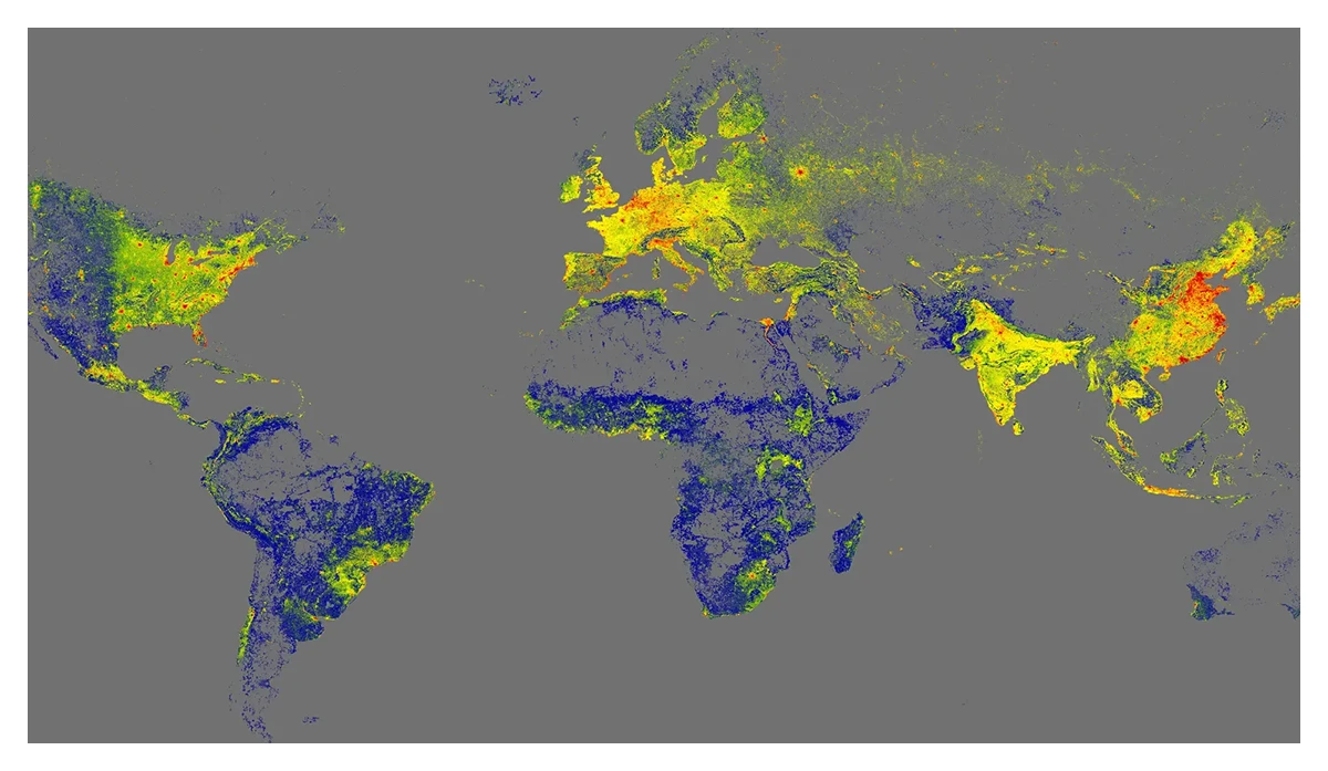
All the World's Buildings Available as 3D Models for the First Time
Xiaoxiang Zhu’s Team Releases GlobalBuildingAtlas
With the GlobalBuildingAtlas, the research team led by MCML PI Xiaoxiang Zhu has created the first high-resolution 3D map of all buildings worldwide. The open data provides a crucial basis for climate research and the implementation of the UN Sustainable Development Goals. They enable more precise models for urbanization, infrastructure and disaster management – and help to make cities around the world more inclusive and resilient.
©TUM
Earth System Science Data: The data enables more accurate models for urbanization, infrastructure, and disaster management
How many buildings are there on Earth – and what do they look like in 3D? The research team led by Xiaoxiang Zhu, holder of the Chair of Data Science in Earth Observation at TUM, has answered these fundamental questions in this project funded by an ERC Starting Grant. The GlobalBuildingAtlas comprises 2.75 billion building models, covering all structures captured in satellite imagery from the year 2019. This makes it the most comprehensive collection of its kind. For comparison: the largest previous global dataset contained about 1.7 billion buildings. The 3D models with a resolution of 3×3 meters are 30 times finer than data from comparable databases.
In addition, 97 percent (2.68 billion) of the buildings are provided as LoD1 3D models (Level of Detail 1). These are simplified three-dimensional representations that capture the basic shape and height of each building. While less detailed than higher LoD levels, they can be integrated at scale into computational models, forming a precise basis for analyses of urban structures, volume calculations, and infrastructure planning. Unlike previous datasets, GlobalBuildingAtlas includes buildings from regions often missing in global maps – such as Africa, South America, and rural areas.
«3D building information provides a much more accurate picture of urbanization and poverty than traditional 2D maps»
Xiaoxiang Zhu
MCML PI
New Perspectives for Sustainability and Climate Research
“With 3D models, we see not only the footprint but also the volume of each building, enabling far more precise insights into living conditions. We introduce a new global indicator: building volume per capita, the total building mass relative to population – a measure of housing and infrastructure that reveals social and economic disparities. This indicator supports sustainable urban development and helps cities become more inclusive and resilient”, explains Xiaoxiang Zhu.
Open Data for Global Challenges
The 3D building data from the GlobalBuildingAtlas provides a precise basis for planning and monitoring urban development, enabling cities to take targeted measures to create inclusive and equitable living conditions – for example, by planning additional housing or public facilities such as schools and health centers in densely populated, disadvantaged neighborhoods. At the same time, the data is crucial for climate adaptation: it improves models on topics such as energy demand and CO₂ emissions and supports the planning of green infrastructure. Disaster prevention also benefits, as risks from natural events such as floods or earthquakes can be assessed more quickly.
The data is already attracting a great deal of interest: The German Aerospace Center (DLR), for example, is examining the use of the GlobalBuildingAtlas as part of the “International Charter: Space and Major Disasters”.
GlobalBuildingAtlas: an open global and complete dataset of building polygons, heights and LoD1 3D models.
Earth System Science Data 17.12. Dec. 2025. DOI GitHub
©TUM
Related
02.04.2026
How AI Avatars Shape Perceived Fairness
Accepted at CHI 2026, this study shows how the race and gender of AI interview avatars shape perceptions of fairness and bias in automated hiring.

24.03.2026
Cybersecurity: “Even Smart Light Bulbs Harbor Risks”
Interview with computer science expert Johannes Kinder on digital security in everyday life.
24.03.2026
MCML Members Win Most Cited Article Award at ECR 2026
MCML researchers win top citation award for ChatGPT radiology study, highlighting benefits and risks in patient communication.